Unprecedented mapping of the Noirmoutier-en-l’Île basin with bathymetric drone
Published on
2 February 2023
A project finally realized, part of the fight against marine submersion
For a long time, the community of communes of the island of Noirmoutier (Vendée, France) wanted to map and acquire knowledge about the three main stretches of the island: the Moulin canal, crossing the village and including the avant-Port de Plaisance, the canal of Arceau further south and the canal of Coëfs.
Their primary desire is to understand the hydrodynamic functioning of these ranges and to monitor their evolution, in order to combat the risk of marine submersion and to improve the safety of the city and the island. In the case of storms, in particular, and during high tidal coefficients, it happens that the canals overflow and flood their environment, sometimes strongly affecting the dwellings and the places around them.
Once obtained, the results are used to analyze the topography of landforms and subsea, and as a numerical field model for hydrodynamic and sedimentary modelling.
The final project consists in the installation of removable hydraulic doors at the entrance of the canals that will close the access in case of storm, protecting the interior of the island from the risk of submersion, like the MOSE project (acronym for MOdulo Sperimentale Elettromeccanico, «electromechanical experimental module») in Venice.
The measurement project really started in June 2022 with the Nantes-based company Ocealis Consulting, chosen to realize the entire land acquisition. With the help of an aerial drone (UAV: «Unmanned Aerial Vehicle»), Christophe Donnard first performs the photogrammetry of the outer port then the lasergrammetry of the trailers with a Lidar, himself installed on the drone.
Once this step has been completed, Ocealis Consulting requests CADDEN for the supply of the marine drone (USV: «Unmanned Surface Vehicle») to conduct the bathymetric surveys, in addition to the aerial lidar surveys concerning only the above-water areas.
The solution
The choice of the USV for bathymetry
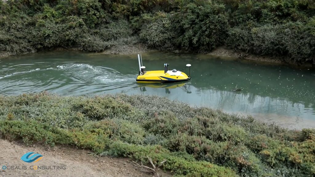
There are many constraints in the canals, which immediately require the use of a compact on-board system for low draught and sometimes narrow passages.
The USV200 bathymetric drone meets these conditions, and the resulting data will then be combined with the aerial drone.
Thus, for three days, and under a beautiful weather, Nathan, our support technician and hydrographer, accompanied Christophe Donnard for the bathymetric survey.
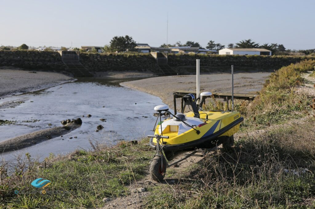
For this mission, the USV200 bathymetric drone was configured with:
R2Sonic 2020 multi-beam echosounder integrated in flush mode to facilitate passage in low draft environments;
The Lidar scans and maps the elements located above the surface of the water (locks, boats, dikes, buildings, etc.), during the mapping of the bathymetric sounder;
An inertial navigation system and professional and precise GNSS receivers;
A mini SVS Valeport probe, connected to the multibeam echosounder and integrated into the marine drone;
An electric winch equipped with an oceanographic probe AML-3, used to measure the speed of water in the harbour.
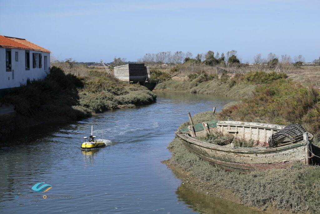
The USV200 bathymetric drone facing a complex environment
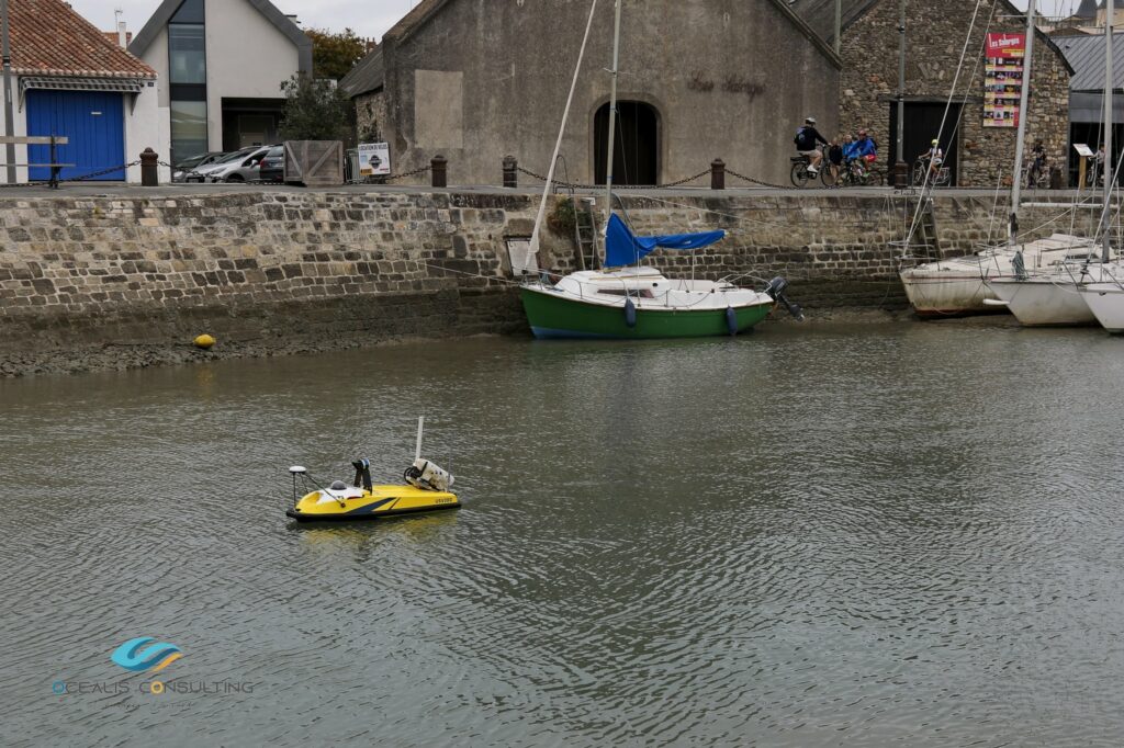
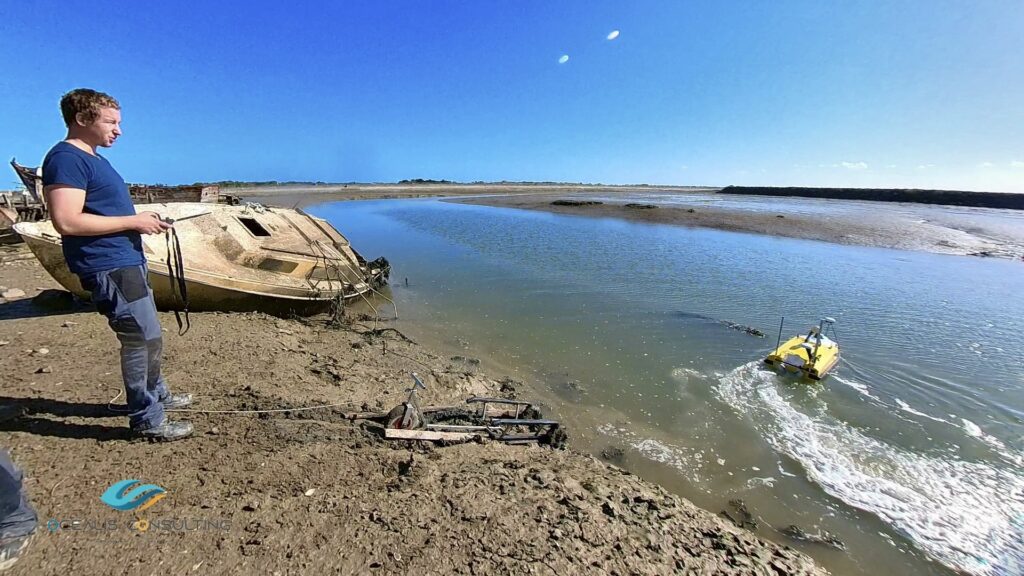
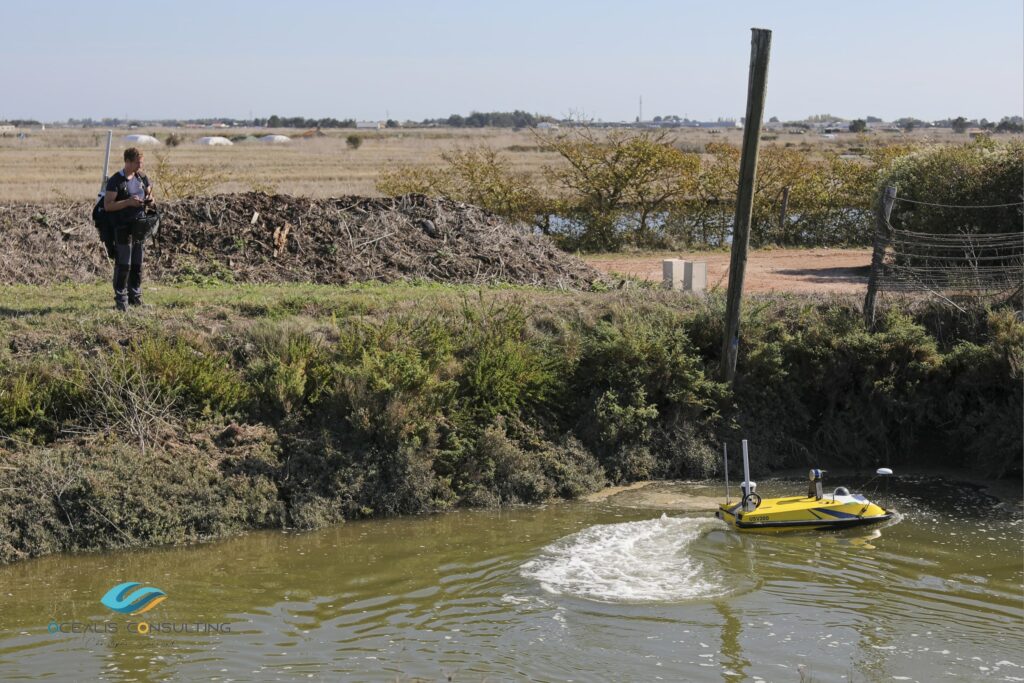
The mission began in the port of Noirmoutier-en-l’Île, in the Moulin region, and continued in the Arceau and Coëfs canals.
Located in the heart of the salt marshes, these stretchers communicate with the sea and are therefore subject to the tides. In order to have complete data, it is sometimes necessary to wait for the tide to rise before launching the marine drone and starting the mission.
In some places, access to soil is relatively complex and does not facilitate operations, especially since the water is launched in muddy soils, but the priority is on the safety of operators.
Using the launch truck and a little elbow grease, the two operators managed to slide the bathymetric drone into the water. The mission can begin.
An atypical and nomadic installation
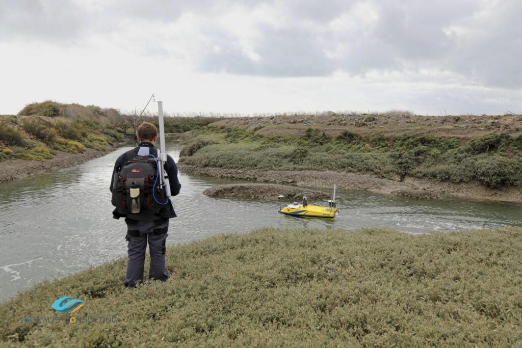
The environment being atypical, the installation of the equipment had to be different. For this situation, it was impossible to stay at a fixed point to supervise the mission.
The solution is self-evident; the GNSS antenna, base station, remote control and the rest of the equipment are installed on the operator in a distributed and optimized manner. Thus equipped, it can easily follow and carry out the mission, while remaining close to the bathymetric USV throughout the survey.
Meanwhile, the operator uses the Qinsy bathymetry software of the QPS suite from a tablet, in order to control and collect the data in real time.
“When the Commune of Noirmoutier turned to Ocealis-Consulting to acquire data on complex sectors, on long linear and difficult to access, the lidar acquisition by Ocealis’s UAV aerial drone-Consulting responded perfectly to the demand for land. For submerged structures on the other hand, we needed another tool, the lidar cannot measure under the surface of the water”, says Christophe Donnard.
“In view of the configuration of the moorings, the narrowness of the channels and the low draughts, the use of a conventional survey vessel was excluded. The choice quickly turned to the marine drone, capable of navigating and acquiring in very shallow depths. Cadden offering a drone of this type, meeting all the required specifications, and accompanying this exceptional project with its expertise and experience, the collaboration with Ocealis-Consulting was made naturally. Cadden perfectly met the requirements of the operation.
In the end, by associating these two companies, we obtain an achievement that is a first in France: an acquisition entirely by drones, on the land and submerged parts of estuarine and wet areas until now not accessible by the usual means, to obtain qualitative data in high resolution, in order to deepen our knowledge of the environment and the environment”, testifies Christophe Donnard.
Did you like this article ? Share it with your colleagues or friends
En poursuivant votre navigation, sans changer les paramètres de votre navigateur, vous acceptez l'utilisation de cookies pour garantir une bonne expérience sur notre site web.