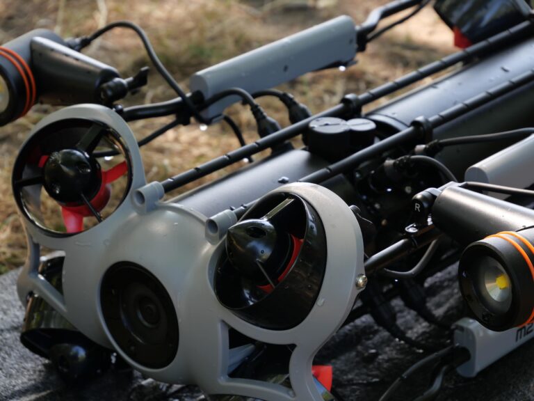
Lidar technology

Table of contents

What is Lidar?

Lidar is an acronym for “LIght Detection And Ranging”. The Lidar is a method of remote sensing in the form of a laser sensor that measures the time of flight (TOF) of the light beams. This technology calculates distances and light intensities in a very precise way to map a 3D environment.
© HESAI

How does Lidar work?

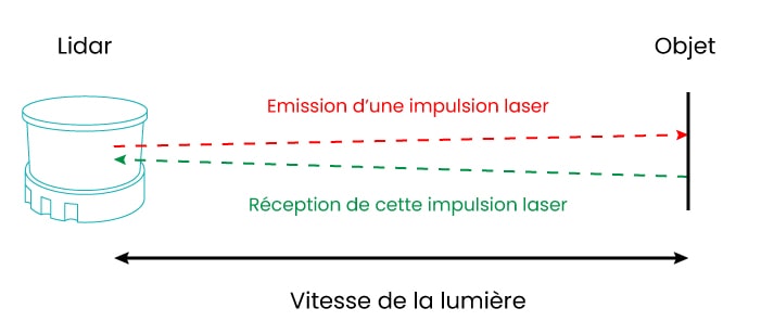
Lidar is a sensor that quickly sends pulses of light, in the form of laser rays, without risk to the human eye (Class 1 Eye Safe), reflected on surrounding objects (tree, pedestrian, car, buildings, etc.) or directly to the ground. The exact distance is calculated by measuring the time it takes the light to move to each object and back to the sensor. Since the speed of light is a constant (about 299 792 458 m/s), the Lidar provides a precise distance between the sensor and an object in real time.

Lidar expliqué avec les émissions émises et reçues

A high-density Lidar sends hundreds of thousands of pulses per second. All these measurements are then collected and processed to create a 3D model of the environment, called a point cloud.


This technology captures millions of data to form a point cloud to represent the studied 3D environment with additional data such as position and shape. Lidars cover ranges from a few meters to a kilometer depending on the model.

What kind of wave does the Lidar use?

The use case of the Lidar will determine the wavelength of the laser. In the context of 3D mapping or obstacle detection, our Lidars operate at wavelengths between 900 and 1550 nm.

The multiplicity of echoes

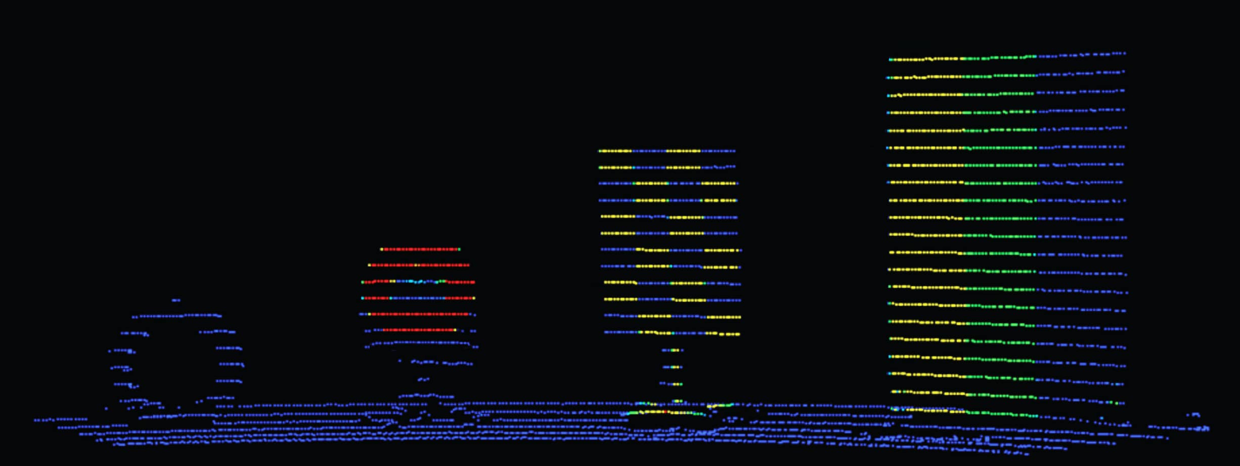
Following each laser pulse, a Lidar can pick up several echoes in return, depending on the type of environment in which it is located (bicycle, tree, building, floor, paint, etc.). Each laser pulse received back by the laser sensor reflected back on different surfaces at different distances.

The strongest echo is the first that the Lidar will capture; it can be a pedestrian, a bicycle or a car. As for the weakest echo, it is the farthest; a tree, a building, a construction or a ground.

If we take the example of an environment with vegetation; the Lidar installed on the roof of a vehicle will first scan the leaves of the trees on the sidewalks of a road in downtown, it is the first echo.

The points of its laser beams will not stop there since they will also reach the buildings behind these same trees, this is the second echo. Most Lidar receive several echoes (2 on average, Lidar Neptec by Lumibird receives 7).

Lidar and light intensity

In addition to differentiating several objects, Lidar sensor technology makes it possible to interpret the colours of reflective surfaces. For example, on a road with road markings where there are many elements such as signs, billboards, graffiti, etc.

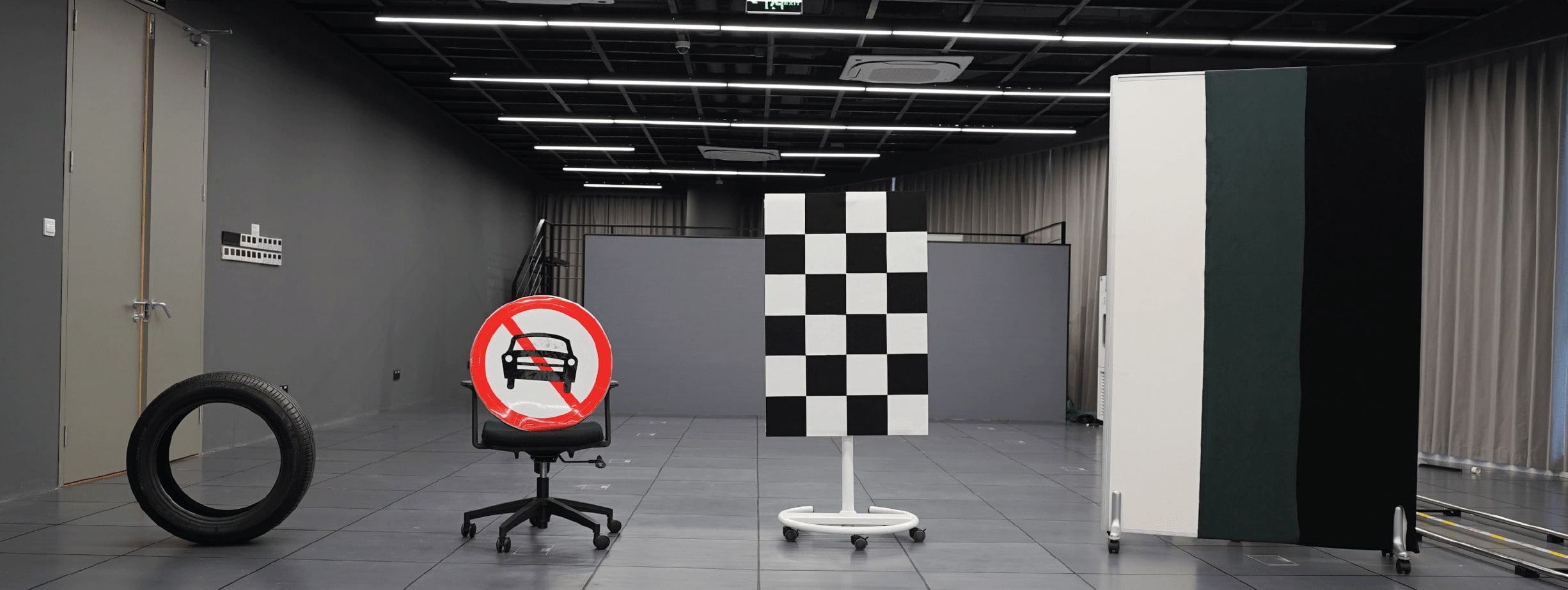
Image 1: Scenario. Image 2: Data with a Lidar Hesai XT.

Lidar hesai comparé situation avant en nuage de points
© Hesai
Lidar hesai comparé situation après en nuage de points
© Hesai

What are the different types of Lidars?

The mechanical Lidar

A mechanical scanning Lidar is designed to collect data on 360° and often present in research and development services for multiple applications (autonomous navigation, road mapping, bathymetry, etc.).

The hybrid solid-state Lidar

The hybrid solid-state lidar operates in 1D or 2D and changes the direction of the laser through an internal mobile mirror. This laser sensor is the consumer solution for mass-produced vehicles.

The solid-state Lidar

A solid-state Lidar does not have any moving mechanical parts, and therefore has a smaller aperture (FOV or ‘Field Of View’) compared to the mechanical Lidar. This lack of mechanical part extends the life of the Lidars, and facilitates the production of these sensors, reducing manufacturing times and costs.

At present, the solid-state Lidar has mainly two technical processes: OPA (Optical Phased Array) and Flash. The principle of OPA is to change the emission angle of the laser beam by adjusting the phase difference of each unit of the transmitter network. The Flash method uses a network of high-density laser sources to emit laser light and quickly cover an area using a high-sensitivity receiver to build a three-dimensional image.

The wind Lidar

Wind Lidar technology is designed to understand static wind movements over the long term (usually a minimum of one year) for various applications:
  • Know the wind movements before installing wind turbines;
  • Determine aircraft wake turbulence (also called wake vortex) in order to avoid accidents at busy airports;
  • Study of clouds, monitoring of air quality and many others…

Which Lidar to choose between Mechanical Lidar or Solid-state Lidar?

Although the two technologies are similar, RAdio Detection And Ranging uses radio waves to measure the flight time of the reflected signal, using a mobile or fixed antenna. The Lidar principle is different since it uses this same process but by measuring the path made by the laser beams emitted, guaranteeing a better accuracy.

What is the difference between 2D Lidar vs 3D Lidar?

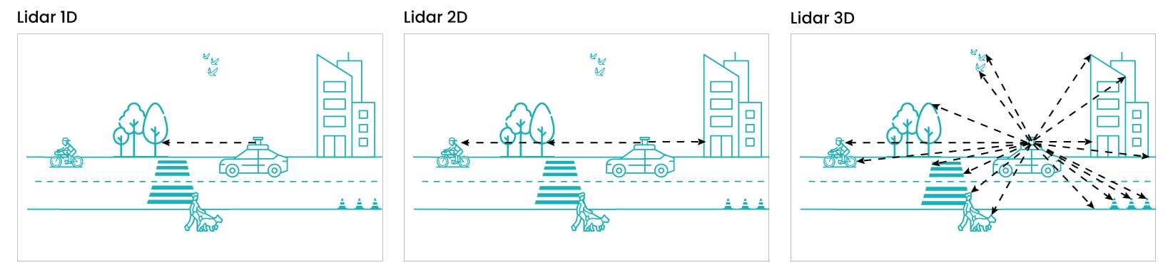
The Lidar 1D sends a single laser pulse on an axis.

The 2D Lidar includes only one laser beam, for detection on a single plane. This laser sensor is mainly used for safety applications (for example for motion detection on a beam from an indoor autonomous vehicle). As part of an autonomous indoor vehicle used in various fields (logistics, distribution, health, etc.), a short-range Lidar 2D laser sensor provides additional precision for human safety (interaction between robots and humans).

The Lidar 3D includes several laser beams (from 16 to 128 according to the models), for simultaneous measurement on several planes.

Différence entre Lidar 1D / Lidar 2D / Lidar 3D

What is the precision scale of a Lidar?

The laser frequency used, the power of the laser diodes, the range, the measurement rate, the number of echoes are all parameters influencing the accuracy of a Lidar, variable from a few millimetres to a few centimetres. Our Lidar laser sensor ranges provide centimetric precision measurements.

What is the difference between Lidar and radar?

Although the two technologies are similar, the radar of the acronym “RAdio Detection And Ranging” uses radio waves to measure the time of flight of the reflected signal, and this thanks to a mobile or fixed antenna.

The principle of Lidar is different since it uses this same process but by measuring the path taken by the emitted laser beams, guaranteeing better accuracy.

What is the difference between the Lidar and the camera?

Lidar and the camera are two detection technologies with radically different principles. The camera only captures 2D images using visible light, so it is quickly limited by lighting or weather conditions (night, fog, snow, rain).

The Lidar measures distances using laser beams and guarantees 3D accuracy regardless of environmental conditions.

Although different, these two complementary technologies are often combined in the same system to improve the detection and identification of objects or people in an environment.

The Lidar’s interest in radar and camera

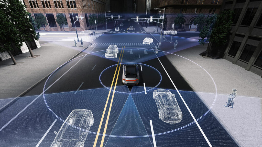
Unlike the ultrasound system, which is too short in range, and the camera, which can only see during the day and in clear weather, the Lidar detects an obstacle several tens of meters away (blind spots, fog, plastic bag, special brightness at sunset, etc.), at night and in rainy weather.

What is the difference between Lidar and sonar?

Unlike Lidar and radar, which both operate with electromagnetic waves, sonar uses acoustic waves. This technology propagates sound in water for the detection and localization of objects underwater.

What is included in a Lidar installation?

Regardless of the type of application, a Lidar is rarely used alone. As a general rule, the installation on an embedded system includes a Lidar, associated with complementary sensors: GNSS system, inertial unit, camera or 3D perception software.

Whether mechanical scanning or solid-state technology, the Lidar laser sensor sends a laser pulse to an object or the ground nearby. It will then calculate a measurement between the pulse and the return one and thus obtain the distance from the Lidar to the object or ground in question.

The addition of a GNSS receiver and an inertial measurement unit in a Lidar measuring system on a vehicle, flying drone or marine drone guarantees the calculation of the precise position (X, Y, Z) of the detected target. The movements of the wearer are compensated by measuring the orientation of the inertial unit.

What is SLAM?

Derived from the acronym ‘Simultaneous Localization And Mapping’, SLAM is a method for simultaneously locating and mapping based on data measured by Lidar. Using the SLAM algorithms, a moving vehicle equipped with GNSS systems and a Lidar can map an unknown environment and obtain georeferenced point clouds.

The SLAM also offers more or less complex perception features in the 3D point cloud, for trajectory analysis, speed measurement, detection of moving objects or not surrounding the vehicle.

What is 3D perception software?

3D perception software analyzes, interprets and exploits spatial data captured by sensors (such as Lidar, cameras or radars), alone or combined with several sensors. Its role is to transform point clouds or 2D or even 3D images into actionable information.
3D perception software is mainly known for the detection and identification of people or objects (vehicles, obstacles), the measurement of distances, volumes or flows (counting people in a public space, calculating stocks in warehouses), real-time monitoring (intrusion detection, alert in case of suspicious movement) or behavioral analysis (pedestrian trajectories, optimization of logistical flows).
© HESAI

Why use a 3D perception software?

In the case of a combined integration with several sensors (Lidar, camera, radar…), the 3D perception software proves essential to improve the understanding of its environment.

It is involved in automating complex tasks (guidance of autonomous vehicles, monitoring of sensitive sites), improving accuracy and safety (detection of obstacles invisible to traditional sensors, reduction of human errors), optimization of costs and efficiency (reduction of inspection times, automation of repetitive processes), decision-making (real-time visualization of 3D data).

What is the difference between 3D perception software and SLAM?

SLAM is a technology through which a system localizes and maps an unknown or dynamic environment in real time. He then creates a 2D or 3D map of this environment to offer an accurate understanding of the space, even without pre-existing landmarks (such as GPS).

3D perception is an application solution that uses technologies such as SLAM (among others) to offer analyses and interpretations of spatial data for concrete applications (security, logistics, space management). This principle detects, identifies and interacts with objects or people in a 3D environment.

In which type of application should a Lidar be used?

The Lidar is used in numerous and varied applications: robotics for detection and recognition of obstacles, aid in autonomous vehicle navigation, bank mapping, monitoring of sensitive areas and intrusion detection, collision alert, navigation without visibility, etc.

Agriculture

Autonomous agricultural machines equipped with Lidar significantly improve the management of plots. The laser sensor Lidar technology maps environments in 3D: map crops, identify areas of stress (water or nutrient), and even detect diseases. Lidar is also used for biomass monitoring or weed detection, offering unparalleled accuracy compared to traditional methods.

Bathymetry

Directly integrated on a USV or hydrographic vessel, the Lidar carries out complete topographies around surface drones during bathymetric surveys. The interest of the Lidar integrated on an aquatic drone is to realize a complete imagery of an environment, by synchronizing the data above and below the water, autonomously and in real time.

Thanks to this combination of sensors, the terrestrial and underwater environment is mapped: banks above water in a port, bridges or coastal habitats. While the echo sounder carries out its bathymetric survey, the Lidar captures its point cloud to create a 3D image of what it perceives in the air.

Defence

Military systems use Lidar for ground surveillance, target reconnaissance, or securing sensitive perimeters. The laser sensor technology has the significant advantage of operating in extreme conditions (fog, snow, rain, etc.), making it a key ally for critical operations.

Construction & engineering

On construction sites and maritime works, the Lidar accelerates projects with real-time monitoring of progress, early detection of deviations from plans (with the BIM process – from the acronym ‘Building information modeling’), and 3D modelling of structures.

For this application case, the Lidar is a wise choice to perform the inspection of bridges, tunnels, or buildings. It helps in the identification of cracks, sagging or possible construction defects. The benefits are significant: reduction of delays, improvement in safety, and compliance with standards, all with millimetric precision.

Entertainment

Very recently arrived in the entertainment industry, the Lidar laser sensor now plays a decisive role and creates immersive experiences that are more real than nature.
The Lidar captures environments, actors or moving objects in 3D point clouds for cinema, television or video games: reproduction of historic cities, realistic environments, special effects, virtual reality.

Forestry and vegetation management

Laser sensor technology is a key tool in the sustainable management of forests and green spaces, particularly in urban environments. Lidar measures the height of trees, assesses canopy density, detects fire-prone areas, monitors tree health, identifies dangerous branches, or optimizes park maintenance.

In urban areas, it prevents tree falls and helps monitor the growth of vegetation along roads and railways. Forest managers thus optimize cuts, monitor regrowth, or fight against illegal deforestation. Coupled with artificial intelligence, the Lidar has the ability to predict certain epidemics before they spread to an entire forest.

Geology and mining

Having become indispensable in geology, Lidar is essential in mining mapping, reservoir modeling, and soil stability monitoring. Detection of landslides, optimization of mineral extraction and risk reduction for workers are also part of the scope of the laser sensor.

In the case of mining industry, the Lidar participates in the identification of new deposits and the precise assessment of the environmental impact of mining sites.

Weather forecast

For meteorologists, the Lidar is now an essential tool for studying clouds, measuring winds, and analyzing air quality. This technology contributes to improving weather forecasts, monitoring storms, or detecting fine particles (pollution, volcanic ash). The data collected feed climate models and help to anticipate extreme events.

Research

Recently, researchers have increasingly used Lidar technology for geophysical (tectonic movements) or environmental studies (biodiversity, deforestation).

Archeology

The Lidar has revolutionized the world of archaeology for the discovery of buried sites and lost cities, without conducting invasive excavations. It reveals ancient structures (villages, roads, tombs, pyramids, ancient villages) under vegetation or soil, and helps preserve heritage by creating 3D models of monuments.

Autonomous vehicle

Car, bus, shuttle, agricultural robot, robot-taxis, robot-trucks… Autonomous means of transport are starting to appear among the manufacturers and the Lidar presents itself as the ideal solution for detecting obstacles (pedestrians, bicycles, animals), calculating their distance and helping to define an avoidance trajectory.

Unlike cameras or radars, the Lidar works day and night, in rain or fog, ensuring optimal safety for autonomous vehicles of level 4 and above.
© HESAI

Examples of uses of Lidar for autonomous vehicles

LAMIH – UPHF

The LAMIH (“Laboratory of Industrial and Human Automation, Mechanics and Computing”) is the joint research unit of the Université Polytechnique Hauts de France (UPHF) and the National Center for Scientific Research (CNRS).

This laboratory aims to develop advanced systems for driving aids in autonomous cars with Lidar. Integrated on the roof of a DS7 car (Stellantis), the Lidar XT32 provided by CADDEN is robust, even outdoors, and suitable for dynamic measurements thanks to its 32 laser beams.
Navya

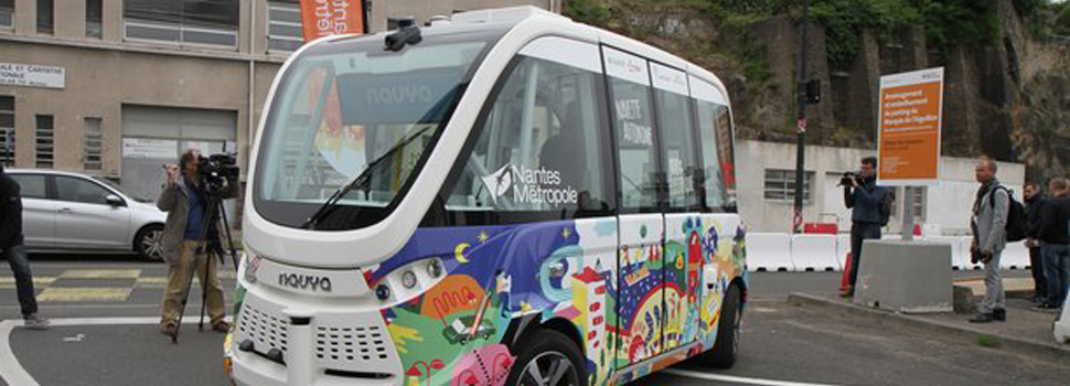
In 2018, the French company Navya was experimenting for a month an autonomous shuttle in the city of Nantes. This was a first for the city, which was temporarily acquiring a self-driving, clean-energy vehicle (although in this test, an agent was present in all vehicles) where a Lidar laser sensor was installed on the front of its roof.

La navette autonome de Navya expérimentée à Nantes pendant un mois

Mobile mapping

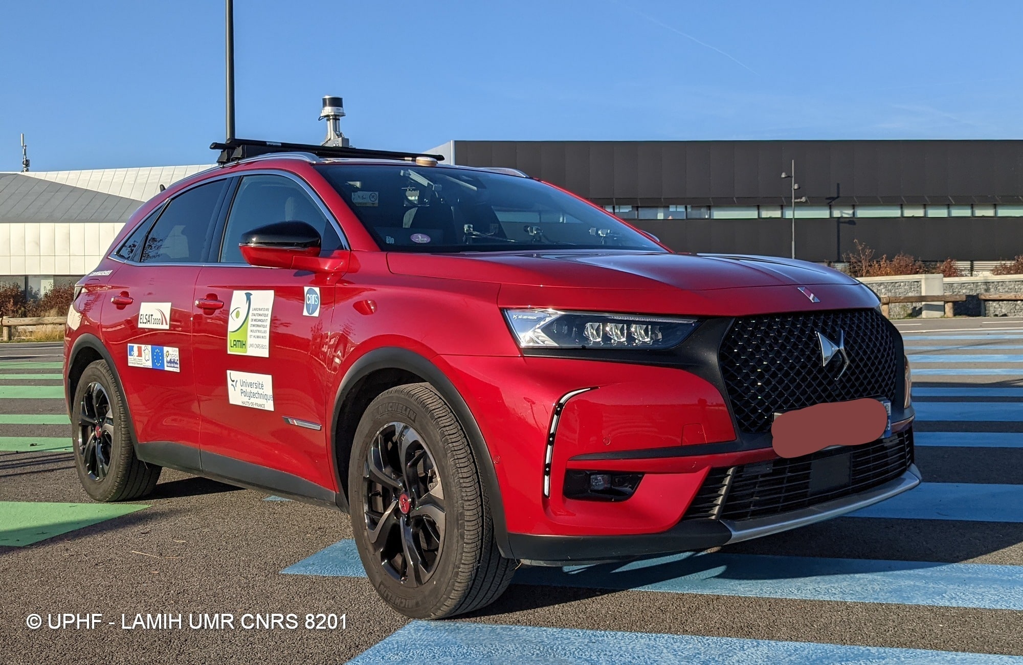
Mobile mapping is a process that includes a vehicle or backpack, equipped with a GNSS system and a Lidar to collect 360° data.

Logistique / AGV & AMR

In industrial sites such as warehouses and factories, the automation of logistical tasks by autonomous vehicles (AGV for ‘Autonomous Guided Vehicle’ and AMR for ‘Autonomous Mobile Robots’, pallet trucks) is associated with Lidars, for navigation in warehouses, the detection of shelves, the placement or removal of parcels and pallets, stock inspection, etc. These autonomous robots move safely while taking care to avoid obstacles (pedestrians, rails…), and optimize their journeys.

© HESAI

Security and surveillance

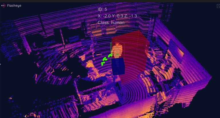
Monitoring sensitive sites (warehouses, plants, water reserves, etc.) is a key issue for many companies and administrations. Associated with a dedicated application, the Lidar laser sensor is installed in strategic locations to guarantee the safety of the premises as employees, we speak about volumetric detection.

Installed at the entry points of a place (airport, station, park, etc.), the interest of the Lidar is the counting of the number of people who enter and leave the same area. With a volumetric detection application used in addition to the Lidar, the body defines the areas to be monitored using laser sensors associated with intelligent software (for example: SLAM).

Smart cities

The Smart City is a new concept of urban development with the aim of improving the quality of life of city dwellers and promoting the working environment of businesses. The Lidar captures data to create 3D digital twins and thus have precise knowledge of buildings, roads, and electrical networks.

Topography

Embedded on an aerial drone, the Lidar sensor performs vertical measurements for mapping vegetation, buildings, transport networks or monitoring power lines.

Lidar is today a reference sensor for making 3D maps and then generating Digital Terrain Models (DTM) for urban planning, development or in risk management cases (floods, landslides).

Did you like this article ?
Share it with your colleagues or friends

Read next